Welcome to whaT'S Up - news about the Technology Solutions Unit's work and our Forest, Fire Management applications (FFM Apps), including FireWeb, eMap, IRIS & EM Drive.
Where does the time go! From our last July 2018 edition, it's time again that we share whaT'S Up in TSU with you.
RATS Amazing Ingenuity Following 8 Nicholson Street Fire
As you may be aware DELWP's 8 Nicholson St. office has been inaccessible since August 22nd.
The office was home to some of our technologies which were impacted severely due to the fire.
For some of us, facing adversity or trying circumstances is an opportunity to shine. Luckily for us, have more than a few of these people working with us at DELWP.
”More”
While the main RATS computer on level four wasn’t destroyed in the fire, our access to it was cut off because of the smoke and a lack of power.
Even before the fire was extinguished our Technology Solutions and State Aircraft units began working on a solution to this technically complex issue, contacting Telstra Wednesday night and having plans in place in time to start work restoring our access Thursday morning.
Communications had to be rerouted to a Telstra exchange, Telstra built new equipment for us allowing us to access that information from their exchange and ultimately bypassing the RATS’ data centre at 8 Nicholson Street. Thanks to the innovation, and ingenuity of our Technology Solutions and State Aircraft units, and in no small part to our very strong working relationship with Telstra, access to RATS was again available by the end of business Thursday.
Paul Rofe Radio Communicatons Lead, says Telstra played an important role too. “The fact that we have such a strong, longstanding relationship with Telstra meant we could get working on addressing the issue as soon as it became apparent.”
Congratulations and well done to all staff involved in resolving this difficult issue so quickly, particularly to TSU's Adam Damen, Paul Rofe, Miles Millward and Tim Kaye.
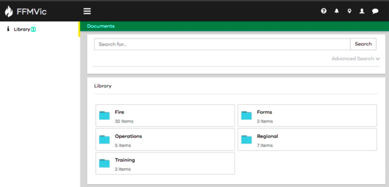
New Feature: The FFMVic Library
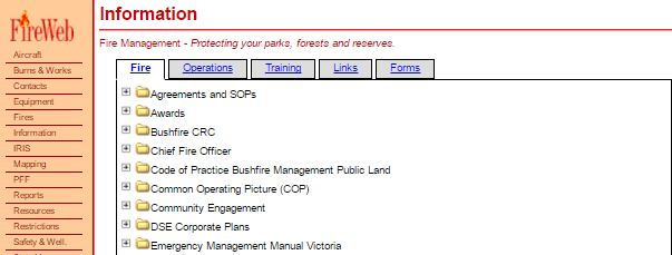
The FireWeb Information Module has been replaced with what is now the FFMVic Library which is part of the FFMVIC Portal (FireWeb Refresh Project).
The FFMVic Library is one of the first, production-ready components of the FireWeb Refresh project.
It contains exactly the same documents as FireWeb’s Information module
”More”
The FFMVic Library features an experimental Advanced Search feature that:
- let’s you search the content of every document (bear with us as we fine tune the speed of this new feature!), and
- displays context snippets in the style of Google search results (so you can be sure you're accessing the right document, each and every time).
Its design and layout also embraces our 'mobile first' ethos so users of tablets and smart phones will have a great experience; even from the field.
FireWeb’s Information module has been the repository for Fire, Operations and Training documentation, and certain forms and links, since around 2000.
As part of the Fireweb Refresh project, we want to hand document management abilities to our users (rather than having to make requests via FFM Support).
Future Improvements to FFMVic Library
The intention in the future is to give control to District and Region users (with authorised access) to upload documents by themselves giving you the ability to upload your own content and keep up your version control from the FFMVic Library.
Old
New
For further information check out the Fireweb Refresh Project News Page
eMap News
All eMap sites have been moved to HTML 5
All eMap sites have been moved to HTML5 viewers, which means that all sites can be accessed from any modern web browser. No longer are we a slave to the tyranny of Internet Explorer! The preferred browser for eMap is Google Chrome - for DELWP users, when we move to Windows 10, Google Chrome will be available by default.
Click on "More" to read about further eMap changes that have occurred since July.
”More”
Update on FMS Line Nominations layer
With FMS currently being re-built, there is no need for the FMS Line Nominations layer to be used. All map features that were created in this layer have been moved across to the Tactical Lines layer, with information recorded in the comments field about the source of the feature. The FMS Line Nominations layer has also been removed from the eMap Fuel Management site.
eMap Water Update
eMap Water now incorporates marine pollution incident data from Australian Maritime Safety Authority (AMSA), and any incident-related observations can now be attached to that incident.
eMap Fuel Management Update
- The majority of features that were attached to FMS burns have now been migrated back to the relevant Burns & Works record, and the team is progressively working through the remainder of these. If you find any duplicate features relating to your burns, you can safely delete the duplicate features..
- eMap Fuel Management - you can now create a feature and attach it to a 'Temporary' burn - which is similar behaviour to the eMap Bushfire site. 'Temporary' features will only be retained for 3 months, so please do not leave features attached to these permanently, as they will not appear in your map outputs, and will be progressively archived and deleted.
- eMap Fuel Management - a 'Property Report' is available which allows you to create a table of properties within a specified distance of a burn. This report can be used to source property owner details from Local Government if required for engagement and notification purposes.
- 'Find A Geographic Feature' tool will be progressively released across all sites. This enables you to search for specific geographic features beyond roads, river and localities. Geographic features can also be searched for from the 'Global Search' tool in the top RH corner of the screen.
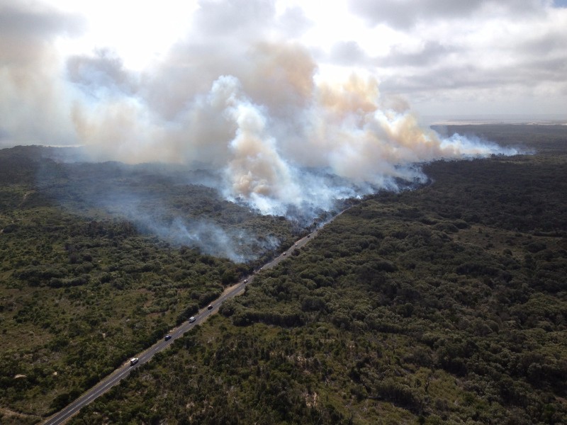
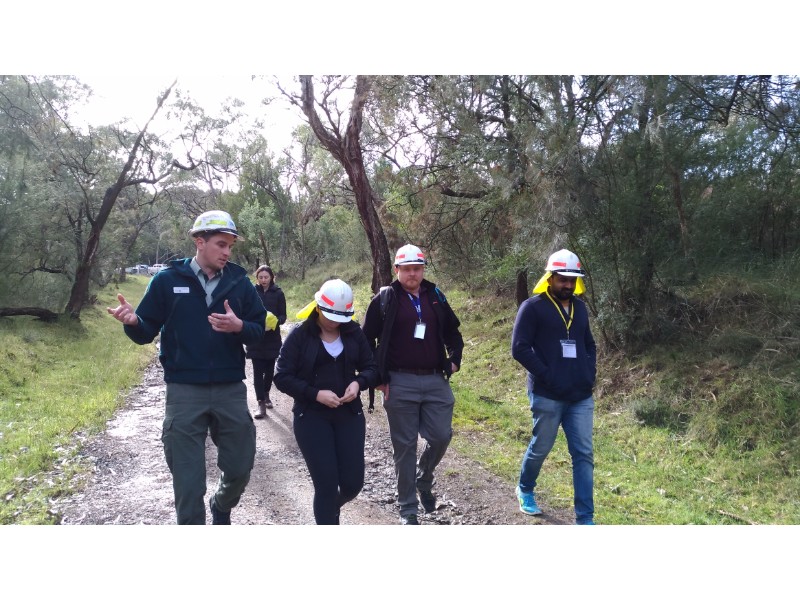
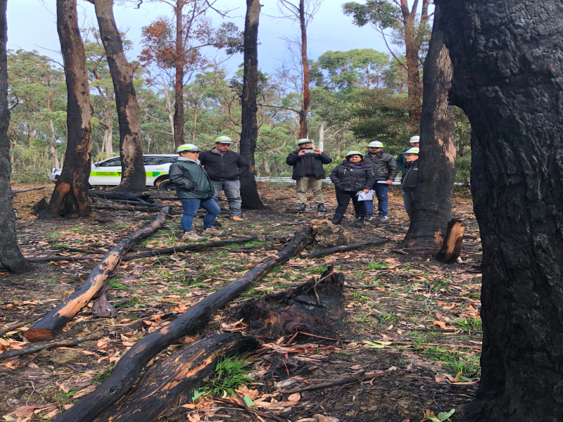
FMS Site Visit to Grampians
whaT's been done
Fuel Management System (FMS), Burns & Works and PBRAT
- Burns & Works page now displays the current years burns list without having to manually filter for this current year
- New forms Planned Burn Risk Assessment Tool Phase 1 (PBRAT) have been developed in UAT to be implemented by 1st of October
- New interfaces have been developed to extract and display burns from the Burns and Works applications
- The FMS project team went to a field visit at Trentham, Midlands in Grampians. A special thank you to Alison and Sam.
eMap
- All eMap sites have been re-released as HTML5 compliant sites, this means that all eMap sites can be accessible via all browsers
We advise using Google Chrome as your preferred browser for all eMap sites. - FMS Line Nomations Layer has been removed from the eMal Fuel Management Site. There is no requirement for the FMS Line Nomination Layer to be used. All map features that were created in this layer last year have been moved across to the the Tactical Lines Layer
- eMap Water now incorporates marine pollution incident data from the Australian Maritime Safety Authority
- eMap Fuel Management - the majority of features that were attached to FMS burns have been migrated back to the relevant Burns & Works record
- eMap Fuel Management - you can now create a feature and attach it to a 'Temporary" burn, please do not leave features attached permanently as the features will only be present for 3 months
- Find A Geographic Feature tool will be progressively released on all sites. It will enable you to search for specific geographic features beyond roads, rivers and localities.
FireWeb
- Progressed improving FireWeb | State Map | Readiness for ICCs, to automate the display of recommended Readiness levels per ICC footprint, based on forecast FDRs
- Improvements made to BoM Automatic Weather Station data feeds, to make more reliable / flexible
- Supported employment of Project Firefighters - data feeds, reports, broker-jobs, and more
(a) addition of multiple new fields required for the CFA to record priority burns in our system
(b) creation of new FireWeb Role to permit that data entry and assigning of that role to selected CFA users. - Updating of Reports to ensure 18/19 variants exist (underway and on-going work)
- Changes made to FireWeb | Burns & Works module to support CFA desire to add several hundred high-priority CFA burns
FireWeb Refresh Project
- FireWeb Information Module has been migrated to the new FFMVic Library which is now live and available for use!
Infrastructure
- RATS has been moved from 8 Nicholson Street, East Melbourne to the Horizon Cloud
this means that RATS will be not be impacted by any issues relating to network outages or emergencies that occur at 8 Nicholson St. - All Horizon Production Windows Security Servers have been patched and all non-production servers have also been patched and verified successfully
- Tested Disaster Recovery switching to Sydney successfully
Feedback
We would love to hear from you, you can provide feedback by commenting on the page below or by clicking here!
whaT's coming up
Fuel Management System (FMS)
- Ability for authorised users to add and approve PBRAT records
FireWeb Refresh Project
- Re-writing FireWeb Refresh Project work which has so far been completed in the ANGULAR coding language which is more powerful, quicker to develop and easier to support
FireWeb
- Advance ability to see forecast Fire Danger Ratings per ICC footprint for today and week ahead on FireWeb | State Map | Readiness screen
- Uploading 2018/2019 planned burn charge codes to FireWeb | Burns & Works
- Ensuring CFA burns recorded in CFA's Buddi system, flow through to DELWP's Planned Burns Notification System (part of Safer Together work)
eMap
- Integration of the Context Cam mobile app. Which allows photo observations to be collected from the field and shared with
Incident Management Teams, which will improve situational awareness - Implementation of a solution to improveSQL performance
- Integration of data feeds from VicRoads relating to oversize overmass road permit conditions. This integration will allow for
personnel to have access to authoritative VicRoads data relating to the operation of oversize overmass vehicles under both emergency and non-emergency conditions - Integration of CFA Resource Tracking data feed into eMap table of contents
Did you know!
eMap Helpsite
Check out our new content in the eMap Helpsite We are progressively building this resource with how-to documents, tips and tricks.
TSU Release Notes and Comms
TSU now have a dedicated page for all our release notes and communications. To keep a track of all the changes and updates we make click here!
Thank You
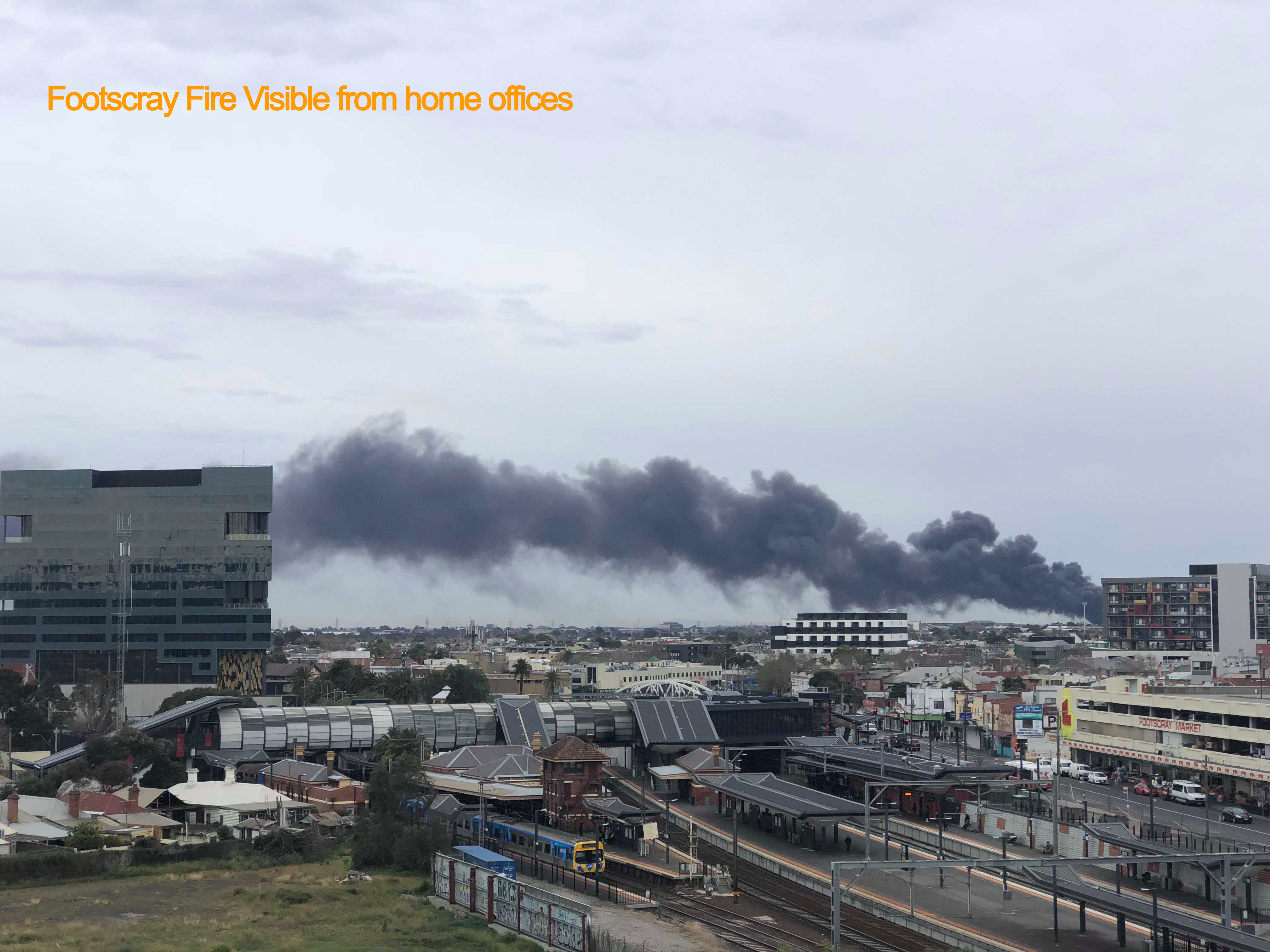
- Thank you to Leanne Buchanan for great foresight shown regarding the move of TSU applications to Horizon (cloud) environment. This has meant that the recent fires at 8 Nicholson Street, East Melbourne and the subsequent closure of the building has not impacted our users of TSU FFM Applications.
- Thanks to DELWP and partner agencies for housing itinerant 8 Nicholson Street staff on very short notice.
- Thank you to Clare Allanson and Gary Turnham for their efforts in preparing the FMS Product Release Plan for June 2019
- Thanks to Alison and Sam Basham ( Midlands) for organising a field visit to view a planned burn site for the new starters in FMS Team
- A huge thanks to Christine Spits (Geospatial Analyst within the eMap team) for the huge amount of work undertaken recently around the FMS re-build and the changes that needed to be made to eMap and our data to accommodate this. What was initially thought to be a simple request and task ended up being far bigger than any of us expected, but thanks to Christine's hard work, the work was completed on time for our most recent release.
About Us
Click here to find more about TSU
Our vision is to create innovative technology solutions that deliver business value and enable a mobile workforce. Technology Solutions Unit (TSU), is part of the Capability and Logistics Branch, Infrastructure and Resources Division, Forest, Fire and Regions Group, within DELWP.
TSU creates in-house applications to enable Forest, Fire and Regions Group (FFRG) and its partner agencies to collaborate and manage information for emergency events and risk management. FFM Applications are the primary source of integrated emergency and risk management information.
TSU key responsibilities:
- Deliver fit-for-purpose technology and systems to meet Forest, Fire and Regions and the emergency management sector requirements
- Coordinate the development of new tools across Forests, Fire and Regions Group
- Provide geospatial systems, development, data management and analysis to support Forest, Fire and Regions and the emergency management sector requirements
- Manage radio communications systems to support Forest, Fire and Regions and the broader emergency management sector requirements
- Collaborate with Corporate Services and fire and emergency management agencies in the delivery of communications and information systems.
TSU is Agile
TSU follows the principles of Agile methodology. This means we are flexible and move swiftly to bring your suggestions to fruition, through adaptive planning, early delivery and continuous improvement.
Our Agile Values
- Individuals and interactions over processes and tools
- Working software over comprehensive documentation
- Customer collaboration over contract negotiation
- Responding to change over following a plan
While we see value in the items on the right, we value the items on the left more.
When you send us an idea, we collect them in what’s known as a backlog – a list of work for prioritisation based on business value. We have one Product Owner per app, who are empowered to make decisions relating to the direction of our applications, and solely accountable for the success of our products.
All suggestions are prioritised based on business value. The Product Owner will contact you to ensure we meet requirements once it reaches the top of the backlog.
Feel free to contact us to discuss the progress of your request. You might like to come and discuss your ideas in person with the Product Owner.